Written by Marco Ramerini. English text revision by Dietrich Köster.
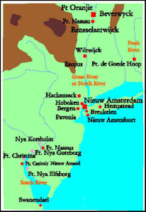
The 17th century Dutch colony of Nieuw-Nederland was situated between the South River (Delaware River) and the Fresh River (Connecticut River) with his center on the North or Great River (Hudson River) practically in the present US States of New York, Delaware, Connecticut and New Jersey.
The Dutch connection with North America began in September 1609, when Henry Hudson, an English Captain in the service of the VOC (Vereenigde Oostindische Compagnie) discovered with his ship “De Halve Maan” (The Half Moon) the river, which today bears his name. He was in search of the Northwest Passage to Asia. Shortly after the return of the Hudson expedition Dutch merchants sent out new expeditions, the aim of all these expeditions was the fur trade with the Indians.
In 1614 the Staten Generaal of the United Provinces of the Netherlands granted a charter for three years to the New Netherlands Company of Amsterdam. The first Dutch settlement in North America was built in late 1614 on Castle island (an island in the Hudson river just south of Albany, NY). This trading post was called Fort Nassau, but this fort frequently lay under water and was consequently abandoned in 1617. In 1621 the newly founded West-Indische Compagnie (WIC) was granted a charter, which included the coast and countries of Africa from the tropic of Cancer to the Cape of Good Hope and also all the coast of America.
In 1624 the first WIC expedition started. A ship with about thirty families of colonists (most of them were Walloons) reached the Hudson or Great River. They anchored near the abandoned Fort Nassau. Later in 1624 a new fort called Fort Oranje was built here on the west side of the river, where Albany now stands. In the same year the Dutch began to build two forts, one on the South River (Delaware) named Fort Nassau and the other on the Fresh River (Connecticut), which was called Fort De Goede Hoop.
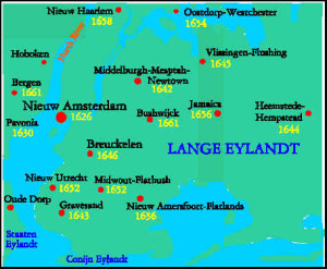
In 1626 a fort was built on Manhattan Island at the mouth of the Hudson River. This fort was called Fort Amsterdam and around it the town of Nieuw Amsterdam developed. It was destined to become the capital of the Dutch colony. In 1628 the population of Nieuw Amsterdam amonted to 270 souls. In 1630 three patroonships were founded: on the South River Swanendael; on the North River at its mouth, Pavonia and at Fort Oranje, Rensselaerswyck. The last, Rensselaerswyck, was the only successful patroonship in New Netherlands. In 1633 a wooden church was erected in Nieuw Amsterdam and in 1642 it was replaced by a stone church inside the Fort.

In March 1638 a Swedish expedition arrived on the South River (Delaware), where they founded the colony of Nya Sverige (New Sweden). The Dutch at Fort Nassau strongly protested. The Dutch reply arrived in 1655, when a Dutch army with more than 300 soldiers made the whole Nya Sverige give in after some resistance on 15 September 1655.
In 1647 the population of New Netherlands was about 1,500-2,000 souls. In 1652 the population of the city of Nieuw Amsterdam had 800 souls. A Municipal Government was given to it in 1652-53 and a Burgomaster was appointed. In 1664 the population of Nieuw Amsterdam amounted to 1,600 souls and the number of inhabitants of the whole New Netherlands was about 10,000 souls.
On 8 September 1664 (during the Second Anglo-Dutch War) the English took possession of Nieuw Amsterdam and they renamed the city New York. By the treaty of Breda (1667) New Netherlands was exchanged with the English for the colony of Suriname, which at that time was a more developed and rich colony.
The Dutch in August 1673 (during the third Anglo-Dutch War) retook possession of New York, the fort was renamed Fort Willem Hendrick, while New York became Nieuw Oranje. But by the treaty of Westminster, which was signed in February 1674, the colony went back to the English. In November 1674 the Dutch flag waved in Nieuw Oranje (New York) for the last time.
[divider]
Description (1643) of Nieuw Nederland (New York and Albany) from a narrative of Father Isaac Jogues
Nieuw Nederland is situated between Virginia and New England. The mouth of the river, which some people call Nassau or Great North River, to distinguish it from another one, which they call the South River and which I think is called Maurice River on some maps, which I have recently seen, is at 40 degrees, 30 minutes. The channel is deep and navigable for the largest ships, which ascend to Manhattan Island, which is seven leagues in circumference and on which there is a fort to serve as the commencement of a town to be built there and to be called New Amsterdam.

This fort, which is at the point of the island about five or six leagues from the river’s mouth is called Fort Amsterdam. It has four regular bastions, mounted with several pieces of artillery. All these bastions and the curtains existed in 1643, but most mounds had crumbled away. Thus one entered the fort on all sides. There were no ditches. The garrison of the said fort and of another one, which they had built still further up against the incursions of the savages, their enemies, consisted of sixty soldiers. They were beginning to face the gates and bastions with stone. Within the fort there were a pretty large stone church, the house of the Governor (called Director General by them) – quite neatly built of brick – and the storehouses and barracks.
On the island of Manhattan and its environs there may well be four or five hundred people of different sects and nations: the Director General told me that there were persons of eighteen different languages; they are scattered here and there on the river, upstream and downstream, as the beauty and convenience of the spot has stimulated everybody to settle: some mechanics, however, who ply their trade, are ranged under the fort; all the others are exposed to the incursions of the natives, who in 1643 actually killed quite some Hollanders and burnt many houses and barns full of wheat. The river, which is very straight and runs in due north-south direction, is at least a league broad before the fort. Ships lie at anchor in a bay, which forms the other side of the island and can be defended by the fort. [….]
No religion is publicly exercised but the Calvinist one, but in reality it is different; besides the Calvinists there are Catholics, English Puritans, Lutherans, Anabaptists (Mennonites) and more in the colony. When anyone comes to settle in the country, they lend him horses, cows etc.; they give him provisions, which he all returns as soon as he is at ease; regarding the land, he pays to the West India Company the tenth of the produce he harvests after ten years. [….]
Ascending the river to the 43d degree, you meet the second Dutch settlement, which the tides reach, but do not pass beyond. Ships of a hundred and twenty tons can come up to it. There are two things in this settlements (which is called Renselaerswijck, i.e. settlement of Renselaers, who is a rich Amsterdam merchant): first a miserable little fort called Fort Oranje, built of logs with four or five pieces of Breteuil cannon and as many pedereros. This has been reserved and is maintained by the West India Company. This fort was formerly on an island in the river; it is now on the mainland towards the Iroquois, a little above the said island. Secondly, a colony sent here by Renselaers, who is the patron. This colony is composed of about one hundred persons, who reside in some twenty-five or thirty houses built along the river, each of them to be found most convenient. In the principal house lives the patron’s agent; the minister has his apartment, in which religious service is performed. There is also a kind of bailiff, whom they call the schout (seneschal), who administers justice. All their houses are merely of boards and thatched with no mason work except the chimneys. The forest furnishing many large pines, they make boards by means of their saw mills, which they have established for this purpose. They found already some pieces of ground, which the savages had formerly cleared, in which they sow wheat and oats for beer and for their horses, of which they have a great number. There is little land fit for tillage, being hemmed by hills, which have poor soil. This obliges them to separate and they already occupy two or three leagues of country. Trade is free to all; this gives the Indians the chance to buy all things at a cheap price. Each Hollander tries to outbid his neighbor, which gives him satisfaction, provided he can gain some profit. [….]
There are many [Indian] nations between the two Dutch settlements, which are about thirty leagues apart. [about 200-250 Km.] [….]
Father Isaac Jogues. From Trois Rivières in Nouvelle France, 3 August 1646.
[divider]
ACADIA WAS ALSO DUTCH
In August 1674 a Dutch ship under Captain Jurriaen Aernoutsz attacked the French fort and military headquarters of Pentagouet in Penobscot Bay (Acadia), which surrendered to it after a siege of two hours; then the Dutch ship sailed to the Saint John River, were it conquered another French fort (Jemseg). This conquest was short-lived. Aernoutsz claimed all Acadia as a Dutch colony, but when he left the forts in search of reinforcements, the Dutch garrison was routed by an expedition of New Englanders. In a “foolish attack” the Dutch Government named Cornelis Steenwyck Governor of the Coasts and Countries of Nova Scotia and Acadia in 1676, but at that time he had only the title and not the land.
[divider]
[divider]
BIBLIOGRAPHY:
NEW NETHERLANDS:
– Various Authors, “The Colonial History of New York under the Dutch”, CD-Rom in 5 volumes. Includes: “Narratives of New Netherland” (Jameson), “History of New Netherland” (O’Callaghan), “History of New York” (Brodhead) and also includes Cadwallader Colden and four Munsell tracts, edited by O’Callaghan
– Condon, Thomas J., “New York Beginnings: The Commercial Origins of New Netherland”, New York University Press, 1968, New York, USA.
– Griffis, W. E. “The story of New Netherland. The Dutch in America”, 292 pp., Houghton, 1909, Boston/New York, USA. – Heywoood, Linda M. & Thornton, John K., (2007) “Central Africans, Atlantic Creoles and the making of the Foundation of the Americas, 1585-1660”, Cambridge and New York : Cambridge University Press
– Jameson, J. Franklin “Narratives of New Netherlands 1609-1664” 480 pp. Charles Scribner’s Sons, 1909, N.Y. USA
– O’Callaghan, E. B., “The History of New Netherland”, 2 vols., D. Appleton, 1848, New York, USA
– Ward, C. “The Dutch and Swedes on the Delaware 1609 – 1664” 393 pp. University of Pennsylvania Press, 1930 Philadelphia, Penn. USA
– Weslager, C.A., “Dutch explorers, traders and settlers in the Delaware valley 1609-1664”, 329 pp., illustrations, University of Pennsylvania Press 1961, Philadelphia, U.S.A.
– Zwierlein, L. D. “Religion in New Netherlands: A History of the Development of the Religious Conditions in the Province of New Netherlands 1623-1664” 327 pp. John Smith Printing Co, 1910, Rochester, N.Y. USA.
ACADIA:
– Champernowne Francis “The Dutch Conquest of Acadie and Other Historical Papers” edited by Charles W. Tuttle and Albert H. Hoyt
– Mahaffie “A land of discord always: Acadia from its beginnings to the expulsion of its people 1604 – 1755”