Written by Geoffrey A. P. Groesbeck
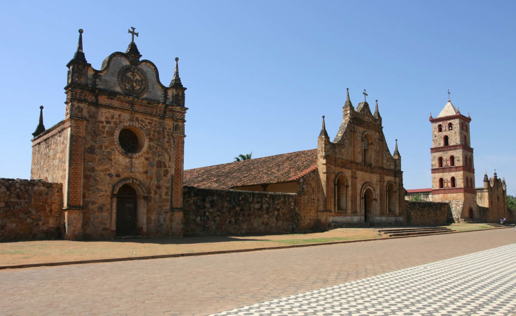
San José de Chiquitos, the third-oldest Jesuit mission in the Chiquitania and one of the prettiest, was founded in 1697 by Felipe Suárez (who later co-founded San Miguel de Velasco to the north) and Dionisio Avila. Relocated in 1706, it was its new location that made it the most important town in the region for more than three centuries, although San Ignacio de Velasco has since surpassed it in importance.
With roughly 12,500 inhabitants and located a little more than halfway between Santa Cruz (180 miles or 290 kms) and Puerto Suárez, it is an important stop along the Santa Cruz-to-Brazil route by train and road, a major ranching centre, and the gateway to two national parks, Santa Cruz la Vieja (Bolivia’s smallest) just outside of town, and the massive Kaa-Iya (Bolivia’s largest) to the south, in neighbouring Cordillera Province. Because of its location and accessibility, San José de Chiquitos will be most travellers’ first or last stop along the Jesuit Missions circuit, depending upon whether one is coming from Brazil or Santa Cruz.
The town is much like what the capital Santa Cruz de la Sierra was seventy years ago: wide, dusty streets out of a Hollywood western movie, complete with cowboys, ranchers, and a charming colonial-era main square. Even amongst the other Jesuit former reducciones, San José de Chiquitos’s unique mission complex will not fail to impress. Its stone construction and late baroque architecture is such that it is literally unique in the world. It is the only extant example of this type of stone mission architecture. It took more than 5,000 people to built it in four stages.
The story of how Santa Cruz de la Sierra came to be located at its present location is complicated. The general sequence of events was as follows. In 1559, Chávez founded Nueva Asunción on the right bank of the Río Grande (also known as the Río Guapay), about 62 miles (100 kms) northeast of where Santa Cruz de la Sierra now sits, and travelled immediately thereafter to Lima to secure his position as the region’s new governor. Although technically not located in the Chiquitania, it nonetheless was the first permanent settlement anywhere near it. Later than same year, Andrés Manso founded the town of La Barranca almost immediately opposite Nueva Asunción, on the left bank of the Río Grande. Chávez saw this as a direct threat to his governorship and took possession of La Barranca, which survived as a separate town until 1564. The inhabitants of Nueva Asunción soon decamped for La Barranca, and the former was abandoned in 1561.
In 1571, the new governor, Juan Peréz de Zurita, announced that the town would have to relocate to the site formerly occupied by La Barranca. This did not happen, and in the end Zurita was deposed by Toledo. Then in 1590, on the banks of the Río Grande further south, Governor Lorenzo Suárez de Figueroa founded yet another new town, San Lorenzo el Real (later known as San Lorenzo de la Frontera). This was to have been the new provincial capital. The following year most of it was moved some six miles (10 kms) across the river and re-named Cotoca. In 1595, some inhabitants transferred to another location 10 miles (16 kms) to the left, on the banks of another major river, the Piraí. This was originally known as Punta de San Bartolomé.
Meanwhile Santa Cruz de la Sierra languished, its population steadily decreasing. In 1604, a representative of the Audencia de Charcas, Francisco de Alfaro, visited the town and attempted to persuade the inhabitants to relocate to San Lorenzo de la Frontera, which still had a remnant living there even after the majority had left, either 13 years earlier (to found Cotoca), or nine years earlier (to help found Punta de San Bartolomé). The cruceños decided to move, but not to Cotoca. Instead, they set up Santa Cruz de la Sierra la Nueva, settling between two other towns also losing population, San Lorenzo de la Frontera on one side and Cotoca on the other. The situation remained thus until 1621, when Governor Nuño de la Cueva decided to fuse together the towns of San Lorenzo de la Frontera and Santa Cruz de la Sierra la Nueva, but leaving Cotoca alone.
But instead of having these towns join together, the next year he ordered everyone to pack up again and move, this time to Punta de San Bartolomé. Cotoca stayed right where it was (and still is), and everybody else merged into one town, which took the name Santa Cruz de la Sierra.
San José is known for its wonderful fabrics, shirts, carvings, walking sticks, and the famous abuelo masks that feature prominently in the region’s folklore and traditions. Local artists here carry on centuries-old traditions.
San José de Chiquitos used to have a sizeable Ayoreo population (in addition to its namesake Chiquitano inhabitants) and several artesanías sell beautiful, rugged hammocks hand-woven by Ayoreo women using centuries-old techniques. These are the equal of the better-known Guarayos hammocks found in Santa Cruz.
As with the other Jesuit former missions of the Chiquitania, the area’s unique music from the Jesuits days retains a prominent place in its culture. San José de Chiquitos boasts at least two schools of music and an orchestra.
Outside town, the Parque Nacional Histórico Santa Cruz la Vieja is well worth an afternoon. Less than three miles (five kms) south of town, it is a wonderful spot to relax and see where the departmental capital of Santa Cruz, at that time part of the Province of Mojos (or Moxos), was founded by the celebrated Spaniard Ñuflo de Chávez on 26 February 1561. The settlement was not a secure one, and although at one time it supposedly held nearly 20,000 inhabitants, it was moved west to a location near the present-day town of Cotoca, and the original site abandoned in 1604.
Written by Geoffrey A. P. Groesbeck
